List of counties in California
The U.S. state of California is divided into 58 counties. Counties are responsible for all elections, property-tax collection, maintenance of public records such as deeds, and local-level courts within their borders, as well as providing law enforcement (through the county sheriff and sheriff's deputies) to areas that do not lie within incorporated cities.
- The county is the default unit of local government (all parts of the state's land are allocated to one of the state's 58 counties). Each county has a Board of Supervisors and is subject to mandatory duties under state law to provide its residents with services like law enforcement, healthcare, road maintenance, and so on. Balancing a county's mandatory and discretionary duties is a very difficult task; any sufficiently injured county taxpayer has standing to sue the county to enforce certain duties where financial distress is no excuse, such as healthcare.
- Residents of a sufficiently large piece of unincorporated county land can incorporate a city. The city government then takes some of the tax revenue that would have gone to the county, and can impose additional taxes on its residents. It can then choose to provide almost all the services usually provided by the county (and more), or provide only a few and pay the county to do the rest. A city in this last arrangement is called a contract city; this type of contract is generally known among lawyers as the "Lakewood Plan", because it was pioneered by the city of Lakewood in 1954.[1]
- The idea of "opting out" of county control in California has been taken to its logical extremes. Almost all of the city of Vernon is one large industrial zone, while almost all of the town of Los Altos Hills is zoned as residential.
- Due to geographical variations in property tax and sales tax revenue (the primary revenue source for cities and counties) and differing attitudes towards priorities, there are variations in the levels of various services from one city to the next. For example, the city of Santa Monica is far more generous when it comes to helping the homeless than other cities in Los Angeles County or the county government.
- Also, county ordinances do not apply to cities unless they are ratified by each individual city. Thus, for instance, in Los Angeles County, a few cities have not ratified the ordinance requiring the posting of restaurant food safety ratings—even though it was passed many years ago—and in those cities, ratings need not be posted.
- The state of California has one consolidated city-county, San Francisco. The city's board of supervisors govern both aspects, and there is both a city police department and a county sheriff, the latter mostly responsible for operating the county jail.
Contents |
First establishment of California counties
On January 4, 1850, the California constitutional committee recommended the formation of 18 counties. They were Benicia, Butte, Fremont, Los Angeles, Mariposa, Monterey, Mount Diablo, Oro, Redding, Sacramento, San Diego, San Francisco, San Joaquin, San Jose, San Luis Obispo, Santa Barbara, Sonoma, and Sutter. On April 22, the counties of Branciforte, Calaveras, Coloma, Colusi, Marin, Mendocino, Napa, Trinity, and Yuba were added. Benicia was renamed Solano, Coloma to El Dorado, Fremont to Yolo, Mt. Diablo to Contra Costa, San Jose to Santa Clara, Oro to Tuolumne, and Redding to Shasta. One of the first state legislative acts regarding counties was to rename Branciforte County to Santa Cruz, Colusi to Colusa, and Yola to Yolo.
The last California county to have been established is Imperial County in 1907.
Table of California counties
The current number of counties was achieved over time by subdivision of many of the larger counties into smaller ones. The links in the column FIPS County Code are to the Census Bureau Info page for that county. The map at the right hand side also shows the FIPS codes for all the counties (on one map for easy reference).
Population Note: County and city populations are counted by two agencies, one the California Department of Finance (CDF) January 2008 data , and also US Census Bureau July 2008 data, using different counting methodology. California claims US Census consistently underreports due to difficulty in tracking immigrants, population data is used to calculate distribution of money for federal programs.
California's postal abbreviation is CA and its FIPS state code is 06.
| County |
FIPS code [2] |
County seat [3] |
Established [3] |
Created from parts of |
Etymology [4] |
Population (CDF 1-08) [5] |
Population |
Area [3] |
Map |
|---|---|---|---|---|---|---|---|---|---|
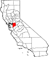
| Alameda County | 001 | Oakland | 1853 | Contra Costa and Santa Clara | Alameda is Spanish for an avenue shaded by trees or a cottonwood grove | 1,543,000 | 1,474,368 | 738 mi² (1,911 km²) |

|
| Alpine County | 003 | Markleeville | 1864 | Amador, El Dorado, Calaveras, Mono and Tuolumne | Named for its location high in the Sierra Nevada mountains | 1,222 | 1,061 | 739 sq mi (1,914 km2) |
|
| Amador County | 005 | Jackson | 1854 | Calaveras | Jose Maria Amador (1794-1883), a soldier, rancher and miner. In 1848, Amador, with several Native Americans, established a successful gold mining camp near the present town of Amador City. In Spanish, the word amador means "one who loves." | 37,943 | 38,238 | 593 sq mi (1,536 km2) |

|
| Butte County | 007 | Oroville | 1850 | Original | From the Sutter Buttes, which were erroneously believed to lie within the county's borders at the time of its creation. | 220,407 | 220,337 | 1,640 sq mi (4,248 km2) |

|
| Calaveras County | 009 | San Andreas | 1850 | Original | From the Calaveras River which in turn is named for the spanish word for skulls | 46,127 | 46,843 | 1,020 sq mi (2,642 km2) |
|
| Colusa County | 011 | Colusa | 1850 | Original | From two Mexican land grants; Coluses (1844) and Colus (1845) | 21,910 | 21,204 | 1,151 sq mi (2,981 km2) |
|
| Contra Costa County | 013 | Martinez | 1850 | Original | Spanish for opposite coast, because Contra Costa County is across San Francisco Bay from San Francisco | 1,051,674 | 1,029,703 | 720 sq mi (1,865 km2) |

|
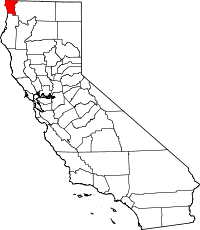
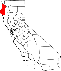
| Del Norte County | 015 | Crescent City | 1857 | Klamath | Spanish for Northern, because Del Norte County is the northwesternmost county in the state. | 29,419 | 29,100 | 1,008 sq mi (2,611 km2) |
|
| El Dorado County | 017 | Placerville | 1850 | Original | From the mythical El Dorado, The Gilded One, in relation to El Dorado County's importance in the California Gold Rush. | 179,722 | 176,075 | 1,712 sq mi (4,434 km2) |

|
| Fresno County | 019 | Fresno | 1856 | Mariposa, Merced and Tulare | From Fresno Creek. In Spanish, Fresno means "ash tree" | 931,098 | 909,153 | 5,963 sq mi (15,444 km2) |

|
| Glenn County | 021 | Willows | 1891 | Colusa | Named for Dr. Hugh J. Glenn (1824-1883), a California businessman and politician. | 29,195 | 28,237 | 1,315 sq mi (3,406 km2) |
|
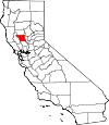
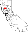
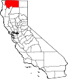
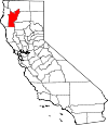
| Humboldt County | 023 | Eureka | 1853 | Trinity | From Humboldt Bay, named after Alexander von Humboldt (1769-1859), a German naturalist and explorer. | 132,821 | 129,000 | 3,573 sq mi (9,254 km2) |
|
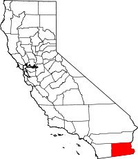
| Imperial County | 025 | El Centro | 1907 | San Diego [6] | From the Imperial Valley, which took its name from the Imperial Land Company. | 176,158 | 163,972 | 4,175 sq mi (10,813 km2) |
|
| Inyo County | 027 | Independence | 1866 | Mono and Tulare | From a Native American word for dwelling place of the great spirit. | 18,152 | 17,136 | 10,192 sq mi (26,397 km2) |
|
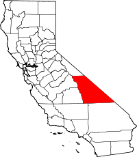
| Kern County | 029 | Bakersfield | 1866 | Los Angeles and Tulare | From the Kern River, named for Edward Kern (1822 - 1863), cartographer for General John C. Fremont's 1845 expedition. | 817,517 | 800,458 | 8,142 sq mi (21,088 km2) |
|
| Kings County | 031 | Hanford | 1893 | Tulare | Kings River – Rio de los Santos Reyes (River of the Holy Kings) to honor the Biblical Magi | 154,434 | 149,518 | 1,390 sq mi (3,600 km2) |
|
| Lake County | 033 | Lakeport | 1861 | Napa | From Clear Lake | 64,059 | 64,866 | 1,258 sq mi (3,258 km2) |
|
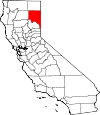
| Lassen County | 035 | Susanville | 1864 | Plumas and Shasta, and now defunct Lake County, Nevada. | Peter Lassen (1800-1859), a Danish naturalist and explorer. | 35,757 | 34,574 | 4,558 sq mi (11,805 km2) |
|
| Los Angeles County | 037 | Los Angeles | 1850 | Original | Spanish for the Angels, abbreviated from El Pueblo de Nuestra Señora la Reina de los Angeles del RĂo de PorciĂşncula (The Village of Our Lady, the Queen of the Angels of the river of Porziuncola). | 10,363,850 | 9,862,049 | 4,060 sq mi (10,515 km2) |
|
| Madera County | 039 | Madera | 1893 | Fresno | Spanish for wood. | 150,887 | 148,333 | 2,138 sq mi (5,537 km2) |
|
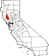
| Marin County | 041 | San Rafael | 1850 | Original | Disputed but may have been a corrupted term for Marina for its location on the San Francisco Bay. | 257,406 | 248,794 | 520 sq mi (1,347 km2) |

|
| Mariposa County | 043 | Mariposa | 1850 | Original[7] | Spanish and Portuguese for butterfly. | 18,406 | 17,976 | 1,451 sq mi (3,758 km2) |
|
| Mendocino County | 045 | Ukiah | 1850 | Original | Antonio de Mendoza (c. 1495 - 1552), viceroy of Spain. | 90,163 | 86,221 | 3,509 sq mi (9,088 km2) |

|
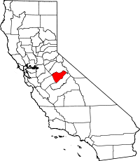
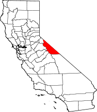
| Merced County | 047 | Merced | 1855 | Mariposa | From the Merced River, or in Spanish El RĂo de Nuestra Señora de la Merced (River of Our Lady of Mercy); named in 1806 by an expedition headed by Gabriel Moraga. | 255,250 | 246,117 | 1,929 sq mi (4,996 km2) |
|
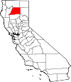
| Modoc County | 049 | Alturas | 1874 | Siskiyou | From the Native American Modoc people. | 9,702 | 9,184 | 3,944 sq mi (10,215 km2) |
|
| Mono County | 051 | Bridgeport | 1861 | Calaveras, Fresno and Mariposa | For a local Native American tribe, the Mono Paiute people. | 13,759 | 12,774 | 3,044 sq mi (7,884 km2) |
|
| Monterey County | 053 | Salinas | 1850 | Original | From Monterey Bay. The name itself is composed of the Spanish words monte (hill) and rey (king). | 428,549 | 408,238 | 3,322 sq mi (8,604 km2) |
|
| Napa County | 055 | Napa | 1850 | Original | For a local Native American tribe, the Napans. | 136,704 | 133,433 | 754 sq mi (1,953 km2) |
|
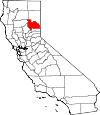
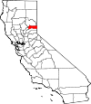
| Nevada County | 057 | Nevada City | 1851 | Yuba | snowfall in Spanish. | 99,186 | 97,118 | 958 sq mi (2,481 km2) |

|
| Orange County | 059 | Santa Ana | 1889 | Los Angeles | From the citrus fruit widely grown in the region at the time the county was formed. | 3,121,251 | 3,010,759 | 790 sq mi (2,046 km2) |
|
| Placer County | 061 | Auburn | 1851 | Sutter and Yuba | Named for the small flakes of gold found in the area during Gold Rush. | 333,401 | 341,945 | 1,503 sq mi (3,893 km2) |

|
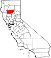
| Plumas County | 063 | Quincy | 1854 | Butte | For the Feather River, "Plumas" meaning "feathers" in Spanish. | 20,917 | 20,275 | 2,554 sq mi (6,615 km2) |
|
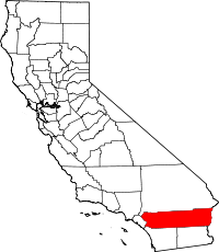
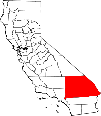
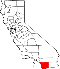
| Riverside County | 065 | Riverside | 1893 | San Bernardino and San Diego | From the city of Riverside being alongside the Santa Ana River and the boundary extends to the Colorado River. | 2,088,322 | 2,100,516 | 7,208 sq mi (18,669 km2) |
|
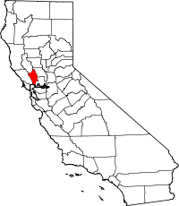
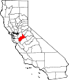
| Sacramento County | 067 | Sacramento | 1850 | Original | From the Sacramento River, itself named for the Santisimo Sacramento (Spanish for Most Holy Sacrament) a reference to the Eucharist. | 1,424,415 | 1,394,154 | 966 sq mi (2,502 km2) |

|
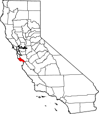
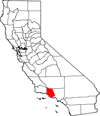
| San Benito County | 069 | Hollister | 1874 | Monterey | in honor of San Benedicto (Saint Benedict), Benito is the diminutive of Benedicto. | 57,784 | 54,699 | 1,389 sq mi (3,597 km2) |

|
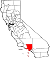
| San Bernardino County | 071 | San Bernardino | 1853 | Los Angeles | Named for Saint Bernardino of Siena. The largest county in the continental U.S. | 2,055,766 | 2,015,355 | 20,062 sq mi (51,960 km2) |
|
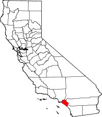
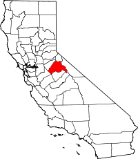
| San Diego County | 073 | San Diego | 1850 | Original | Named for San Diego Bay, itself named for Saint Didacus of Alcalá, or San Diego de Alcalá in Spanish. | 3,146,274 | 3,001,072 | 4,204 sq mi (10,888 km2) |
|
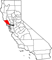
| San Francisco County | 075 | San Francisco | 1850 | Original | Francis of Assisi (1181-1226), a Roman Catholic saint and founder of the Order of Friars Minor (Franciscans). | 845,559 | 845,559 | 47 sq mi (122 km2) |
|
| San Joaquin County | 077 | Stockton | 1850 | Original | Spanish for Saint Joachim. | 685,660 | 672,388 | 1,399 sq mi (3,623 km2) |
|
| San Luis Obispo County | 079 | San Luis Obispo | 1850 | Original | Spanish for St. Louis, the Bishop. | 269,337 | 265,297 | 3,304 sq mi (8,557 km2) |
|
| San Mateo County | 081 | Redwood City | 1856 | San Francisco | Spanish for Saint Matthew | 739,469 | 712,690 | 449 sq mi (1,163 km2) |

|
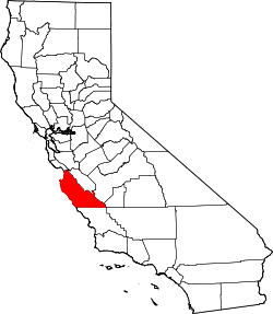
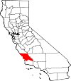
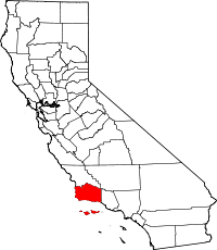
| Santa Barbara County | 083 | Santa Barbara | 1850 | Original | Spanish for Saint Barbara. | 428,655 | 405,396 | 2,738 sq mi (7,091 km2) |
|
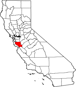
| Santa Clara County | 085 | San Jose | 1850 | Original | Spanish for Saint Clare, for the Santa Clara Valley and the Mission town of Santa Clara. | 1,837,075 | 1,764,499 | 1,291 sq mi (3,344 km2) |
|
| Santa Cruz County | 087 | Santa Cruz | 1850 | Original | Originally called Branciforte County, was named after the city of Santa Cruz, which, in turn, took its name from La MisiĂłn de la ExaltaciĂłn de la Santa Cruz (Mission of the Exaltation of the Holy Cross), which was established on the site of the town in 1791. | 266,519 | 253,137 | 446 sq mi (1,155 km2) |
|
| Shasta County | 089 | Redding | 1850 | Original | After Mount Shasta despite the fact the volcanic peak isn't located in the county per se. | 182,236 | 180,214 | 3,786 sq mi (9,806 km2) |
|
| Sierra County | 091 | Downieville | 1852 | Yuba | Mountain range in Spanish. | 3,380 | 3,263 | 953 sq mi (2,468 km2) |
|
| Siskiyou County | 093 | Yreka | 1852 | Shasta and Klamath | County named after Siskiyou Mountain Range; etymology of Siskiyou is disputed | 45,971 | 44,542 | 6,287 sq mi (16,283 km2) |
|
| Solano County | 095 | Fairfield | 1850 | Original | From an Indian Chief, Chief Solano of the Suisunes, a Native American tribe of the region. | 426,757 | 407,515 | 828 sq mi (2,145 km2) |

|
| Sonoma County | 097 | Santa Rosa | 1850 | Original | After the village of Sonoma. | 484,470 | 466,741 | 1,576 sq mi (4,082 km2) |
|
| Stanislaus County | 099 | Modesto | 1854 | Tuolumne | For the Stanislaus River, which was named for a Yokut Indian named Estanislao | 525,903 | 510,694 | 1,495 sq mi (3,872 km2) |
|
| Sutter County | 101 | Yuba City | 1850 | Original | Named for Johann Augustus Sutter (a.k.a. John Sutter) (1803–1880), a Swiss pioneer of California known for his association with the California Gold Rush. His ranch land was originally named Nueva Helvetia after his homeland of Switzerland in Latinized-Spanish. | 95,878 | 92,207 | 603 sq mi (1,562 km2) |

|
| Tehama County | 103 | Red Bluff | 1856 | Butte, Colusa and Shasta | For a local Native American tribe, the Tehama. | 62,419 | 61,550 | 2,951 sq mi (7,643 km2) |
|
| Trinity County | 105 | Weaverville | 1850 | Original | From the Trinity River which in turn was named after the coastal town of Trinidad, California | 13,966 | 14,317 | 3,179 sq mi (8,234 km2) |
|
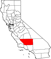
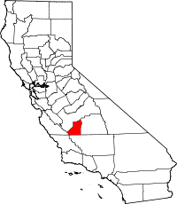
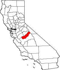
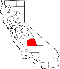
| Tulare County | 107 | Visalia | 1852 | Mariposa | For a dry lake, Tulare Lake on the western end of the | 435,254 | 426,276 | 4,824 sq mi (12,494 km2) |
|
| Tuolumne County | 109 | Sonora | 1850 | Original | The name for the Tuolumne River (twah'-luh-me) has as many possible meanings as it does spellings. The original meaning of the word "Tuolumne" may have been "cave people" or "stone wigwams," both taken from the history of tribes known as "Taulamnell," or "Tahualamne," or Yokuts Indians living near Knights Ferry in the rocks and recesses by the river. Another theory is that "Tuolumne" is derived from a Central Sierra Miwok word "talmalmne" whose meaning is unclear today. | 56,799 | 55,644 | 2,236 sq mi (5,791 km2) |
|
| Ventura County | 111 | Ventura | 1872 | Santa Barbara | Abbreviation of San Buenaventura, Spanish for St. Bonaventure. | 831,587 | 797,740 | 1,846 sq mi (4,781 km2) |
|
| Yolo County | 113 | Woodland | 1850 | Original | For a local Native American tribe, the Yolans. | 199,066 | 197,658 | 1,012 sq mi (2,621 km2) |

|
| Yuba County | 115 | Marysville | 1850 | Original | For the Yuba family, who owned ranchos in the Sacramento River Valley. | 71,929 | 73,067 | 630 sq mi (1,632 km2) |
 |
Defunct counties
- Klamath County was created in 1851 from the northern half of Trinity County. Part of the county's territory went to Del Norte County in 1857, and in 1874 the remainder was divided between Humboldt and Siskiyou counties.
- Pautah County was created in 1852 out of territory which, the state of California assumed, was to be ceded to it by the United States Congress from territory in what is now the state of Nevada. When the cession never occurred, the California State Legislature officially abolished the never-created county in 1859.
See also
- Lists of school districts in California by county
Notes
- ↑ Reynolds, 48-49.
- ↑ "EPA County FIPS Code Listing". EPA.gov. http://www.epa.gov/enviro/html/codes/ca.html. Retrieved 2008-02-23.
- ↑ 3.0 3.1 3.2 National Association of Counties. "NACo - Find a county". http://www.naco.org/Template.cfm?Section=Find_a_County&Template=/cffiles/counties/state.cfm&state.cfm&statecode=CA. Retrieved 2008-04-30.
- ↑ Sanchez, Nellie Van de Grift (1914). Spanish and Indian Place Names of California: Their Meaning and Their Romance. San Francisco: A.M. Robertson. OCLC 4268886. http://books.google.com/books?id=gKgYAAAAIAAJ&printsec=titlepage.
- ↑ California Department of Finance. "2008 Population Estimate". http://www.dof.ca.gov/research/demographic/reports/estimates/e-1_2006-07/documents/E-1table.xls. Retrieved 2008-05-30.
- ↑ The most recent county formed.
- ↑ Mariposa County was the largest of the state's original counties, but territory that was once Mariposa is now 12 other counties -- Fresno, Inyo, Kern, Kings, Los Angeles, Madera, Merced, Mono, San Benito, San Bernardino, San Luis Obispo, and Tulare.
External links
- California State Association of Counties
- State map showing the county names and linking to county data
- California County Formation Maps; familyhistory101.com Shows the changing boundaries of the Counties from 1850 to 1925.
|
|||||
|
|||||||||||||||||||||||